
ПРОВЕРИТЬ НАЛИЧИЕ
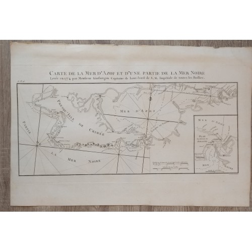
SEA OF AZOF & BLACK SEA CRIMEA RUSSIA UKRAINE ANTIQUE MAP 1784 DELESPINASSE
📢 Guaranteed original 1784 printing. Not a modern reproduction.
📌Carte de la Mer d'Azof et d'une partie de la Mer Noire, Leveee en 1774 par Monsieur Kinsbergen Capitaine de haut-bord de S.M. Imperiale de toues les Russies.
📖 Description: Striking and highly detailed fine unusual large copper engraved map of the Crimean Peninsula with the Black Sea and the Sea of Azov in Russia. The map is filled with excellent topographic details on place names, depth and soundings. Inset map at the lower right quadrant titled "Plan du Dйtroit de Zabache". A title to the top, two mileage scales, a fleur-de-lis and rhumb lines adorn the map.
The map, engraved by Pierre Franзois Tardieu, is based upon the Jan-Hendrki Van Kinsbergen's map.
🧾 Jan-Hendrki Van Kinsbergen's map of Crimea was the first printed map of the Crimea, following its annexation by Russia.
📖 The first edition of Van Kinsbergen's map appeared in 1776. The map is based on observations made by Van Kinsbergen and the Russian Navy, shortly after the conclusion of the Russian-Turkish War, and includes a remarkable amount of topographical detail. During the Russian-Turkish war of 1768-1774, and again in 1783 in connection with the annexation of the Crimea, an intensive effort to map the Black Sea was conducted by the Russian Navy. Among the earliest maps to derive from this work is Jan-Hendrik Van Kinsbergen's map of the Crimea, first published in 1776.
👴 Captain Jan Hendrik van Kinsbergen (1735-1819) was a Dutch officer invited by Catherine II to serve in the Russian Navy.
🧾Source: Nicolas-Gabriel Le Clerc. Histoire physique, morale, civile et politique de la Russie ancienne & moderne. Paris & Versailles: Froullй & Blaizot, 1783-1794.
References: Cohen/Ricci, 613; Brunet, III, 916; Lewine S., 302; Sander, 1138.
📖 Striking and highly detailed fine unusual copper engraved map featuring an aerial plan of Bruges, Belgium, during the Siege of the city, at the time of the Spanish Succession War. The plan shows the city with his buildings, churches, streets, town walls and surrounding landscape. A simple title cartouche to the top left quadrant, a mileage scale and a numbered key adorn the sheet.
📆Date: 1784 ( undated )
🖼 Dimension: Paper size approx.: cm 49,2 x 32,9
📌Condition: Very strong and dark impression on good paper. Paper with chains and wiremarks. Sheet uncolored. Wide top and lower margins. Good right lateral margins. Left lateral margin cut very shortly. Corners partially missing. Small foxing and browning. Conditions are as you can see in the images.
👩🦱 Writer: Louis-Nicolas de Lespinasse (1734 -1808), called the Chevalier de Lespinasse , has been a French Artist.
👴 Mapmakers: Pierre Franзois Tardieu (1711 - 1771) was a French engraver and mapmaker active in Paris during the middle part of the 18th century and a member of the large and prolific Tardieu family.
10707
- Product Code: 10707
- Availability: In Stock