
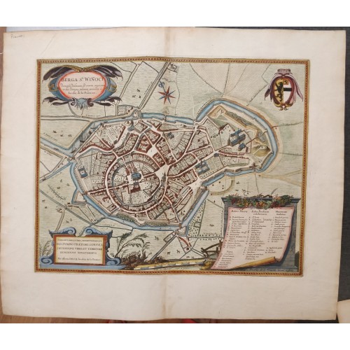
BERGUES FRANCE 1649 BLAEU UNUSUAL ANTIQUE ORIGINAL COPPER ENGRAVED CITY VIEW
Description
Berga S.ti Winoci dimensa delienata ad vivum expressa in hoc denique proiecta а Iacobo de la Fontaine.
Description: Striking and highly detailed fine unusual 1649 Blaeu's copper engraved map featuring an aerial plan of the French City of Bergues. The view shows the city with his buildings, churches, streets, gardens, bridges, town walls, moat and surrounding landscape. A strapwork title cartouche, an armorial, a compass rose, a large strapwork key catouche, frame-style borders, a mileage scale and a strapwork dedicatiory cartouche adorn the sheet. Latin text on the verso.
The town's name derives from the Dutch groene berg, which means "green hill". According to legend, St Winnoc, son of the Breton king, retired to Groenberg, a hill on the edge of the coastal marshes (see Marcae below). His establishment soon developed into a small monastery. In 882, when the Normans began their incursions, the Flanders count Baudouin II built primitive fortifications. Later, about 1022, count Baudouin IV built Saint-Winnoc church and interred the relics of St Winnoc there. This church formed the basis of an abbey. Trade was aided by proximity to the sea, which had not yet receded to Dunkirk, and the abbey. Bergues was chartered in 1240, and its independence was later expressed in the construction of a belfry. It became a port and textile center of regional importance, and part of the Hanseatic League. Its wool market began in 1276 and over the following centuries it was fortified and maintained its independence from France. In 1583, Bergues was besieged and conquered by Alexander Farnese, but king Philip II of Spain allowed it to be rebuilt, establishing the present appearance of the town. Bergues became a major port city and eventually was attached to France by the Treaty of Aix-la-Chapelle in 1668. Louis XIV later developed Dunkirk, and Bergues was eclipsed as a major port. After the French Revolution, its decline continued. Bergues was devastated by bombardment in World War I, and again in 1940 during the Battle of Dunkirk. The city was entered on 2 June that year, and 80% of it was ruined during World War II.
Date: 1649 ( undated )
Dimension: Paper size approx.: cm 60,9 x 51,9
Condition: Very strong and dark impression on good paper. Paper with chains and wiremarks. Map contemporary handcolored. Wide margins. Corners partially missing. Small foxing and browning. Small marginal tears. Map folded. Conditions are as you can see in the images.
Mapmaker: The Blaeus: Willem Janszoon, Cornelis & Joan
Willem Jansz. Blaeu and his son Joan Blaeu are the most widely known cartographic publishers of the seventeenth century.
Willem Jansz. (also written Guilielmus Janssonius) = Willem Janszoon Blaeu, was born in Uitgeest (Netherlands), near Alkmaar in 1571. He studied mathematics under Tycho Brahe and learned the theory and practice of astronomical observations and the art of instrument- and globe making.
Joan Blaeu, born in Amsterdam, 1596, became partner in his father’s book trade and printing business.
BERGUES FRANCE 1649 BLAEU UNUSUAL ANTIQUE ORIGINAL COPPER ENGRAVED CITY VIEW
- Product Code: 10714
- Availability: In Stock