
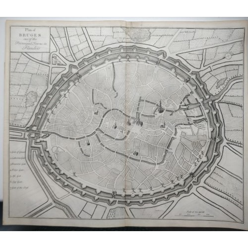
1735 CLAUDE DU BOSC ANTIQUE ORIGINAL COPPER ENGRAVED CITY MAP
ANTIQUE COPPER ENGRAVED CITY MAP OF BRUGES.BELGIUM 1735
Condition:
--not specified
BRUGES BELGIUM 1735 CLAUDE DU BOSC ANTIQUE ORIGINAL COPPER ENGRAVED CITY MAP
Description
Plan of Bruges one of the Principal Towns in Flanders.
Description: Striking and highly detailed fine unusual copper engraved map featuring an aerial plan of Bruges, Belgium, during the Siege of the city, at the time of the Spanish Succession War. The plan shows the city with his buildings, churches, streets, town walls and surrounding landscape. A simple title cartouche to the top left quadrant, a mileage scale and a numbered key adorn the sheet.
The War of the Spanish Succession was triggered by the death of Charles II of Spain, who had no children. He left the Spanish throne to Philip of Anjou, a member of the French House of Bourbon, but the Archduke Charles of Austria also felt he had a claim to the throne. The Grand Alliance of Great Britain, the Dutch Republic, the Holy Roman Empire and Habsburg Spain, declared war on France and Bourbon Spain in May 1702.
Date: 1735 ( undated )
Dimension: Paper size approx.: cm 45,4 x 37,9
Condition: Very strong and dark impression on good paper. Paper with chains. Sheet uncolored. Goodmargins. Corners partially missing. Small foxing and browning. Light white line in the basal part near the central fold due to the folding of the sheet during the pression of the incision. Small tear at the top near central folding affecting the sheet repaired on the verso. Sheet partally reinforced on the verso. Sheet folded. Conditions are as you can see in the images.
Writers: Claude Du Bosc (also spelled Dubosc and DuBosc; c. 1682–c. or after 1746) was a French engraver, publisher, and printseller who spent much of his career in London.
BRUGES BELGIUM ANTIQUE ORIGINAL COPPER ENGRAVED CITY MAP 1735 CLAUDE DU BOSC
- Product Code: 10706
- Availability: In Stock