
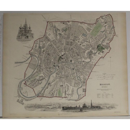
MOSCOW RUSSIA 1836 S.D.U.K. UNUSUAL ANTIQUE ORIGINAL STEEL ENGRAVED CITY MAP
Description
Moscow
Description: Striking and highly detailed fine unusual 1832 Society for the Diffusion of Useful Knowledge' steel engraved map featuring an aerial plan of Moscow, Russia. The map provides a highly detailed bird’s eye view of the city as it was in 1836. Located on the banks of Moscow River, next to which the Kremlin sits, the city is depicted so accurately that it would be possible to use it today for navigating much of the city centre.
Historically speaking, after its founding in the 12th century CE by Rurikid prince, Yuri Dolgoruky, the city grew rather rapidly considering the enormous obstacles faced by its inhabitants. By the time Yuri’s son Ivan became Grand Prince, the city was thriving and the Metropolitan of the Russian Orthodox Church had moved the seat of its See from the city of Wladimir to Moscow.
Moscow’s environs were typically wetlands, difficult to drain, and home to myriad disease carrying insects. Despite these conditions, with its wooden kremlin (meaning fortress in Russian) at its centre, which was replaced by the brick one extant today with its famous toothed walls, the city continued to grow, maintaining its circular shape, with city walls built and extended from time to time to protect its ever increasing populace.
The map clearly depicts some of these early walls, and delineates some primary routes of transportation which exist to this day. The inner circle road around the oldest part of the city, which is situated north of the river, is easily identifiable as is the so-called Garden Ring which encircles a larger area of the city. The old outer walls with their gates are outlined in red.
The Kremlin’s major buildings are depicted and named, as are major streets, smaller ones and even lanes and byways. Convents and monasteries, government buildings such as barracks and munitions powder magazine are shown. In the upper left quadrant an image of the marvelous Saint Basil’s Cathedral on Red Square is depicted. Below the map is a view of the beautiful Novodevechy Convent, where Peter the Great kept his sister imprisoned for her insurrection. Today the area covered by this map forms the very centre of the modern sprawling megalopolis which is home to more than 12.5 million.
The map has been published in 1836 by Baldwin & Craddock. for the S.D.U.K. Atlas.
The Society for the Diffusion of Useful Knowledge (S.D.U.K.) Atlas was initially issued in parts over several years by Baldwin and Craddock to promote the society's mission of egalitarian self-education. The first S.D.U.K. began appearing in 1829 when the society contracted John Walker to produce the first proofs. The first S.D.U.K maps were produced serially by Baldwin and Craddock and issued in 2 map batches, priced at 2 shillings each. The series, originally anticipated to feature 50 maps, ultimately contained 200 and took over 14 years to produce. The initial production was completed in 1844 when the whole was issued in its first compiled atlas edition. Around 1842, following the 1837 bankruptcy of Baldwin and Craddock, publication of the atlas was taken over by the Society itself, who issued editions in 1838, 1839, 1840, 1841, and 1842. Overburdened by the work of publishing, they then outsourced the publication to Chapman and Hall in 1842. Chapman and Hall produced editions in 1842, 1843, and 1844. Dissatisfied with the quality of Chapman and Hall printing, the Society turned to another publisher, Charles Knight, who issued editions under the auspices of the Society in 1844, 1845, and 1846. In 1846 Knight officially acquired the plates in his own right and reissued in revised editions until 1852, when he sold them to George Cox. Cox in turn sold them to Edward Stanford who published them from 1856 well into the 1860s. The S.D.U.K. Atlas is known for the quantity and quality of its maps. The S.D.U.K. published many maps of areas largely ignored by other publishers. The many city plans incorporated into the atlas are particularly admired and are the highlight of the S.D.U.K.'s long map publishing history. As a whole the S.D.U.K. Atlas was groundbreaking in terms of quality, scope, and being offer at a cost effective price point.
Date: 1836 ( dated )
Dimension: Paper size approx.: cm 41,1 x 34,3
Condition: Very strong and dark impression on good paper. Map old original colored. All the margins cut very shortly. Corners partially missing. Small foxing and browning. Conditions are as you can see in the images.
Mapmakers: The "Society for the Diffusion of Useful Knowledge" (1826 - 1848) was a Whiggish organization founded in 1828 at the instigation of idealistic British lord Henry Peter Brougham.
Publisher: Robert Baldwin and Cradock were London based publishers working in the early to mid 19th century.
MOSCOW ANTIQUE ORIGINAL STEEL ENGRAVED CITY MAP 1836
- Product Code: 5248
- Availability: In Stock