NORTHERN RUSSIA FINLAND ESTONIA 1788 BRION DE LA TOUR UNUSUAL ANTIQUE COPPER ENGRAVED MAP
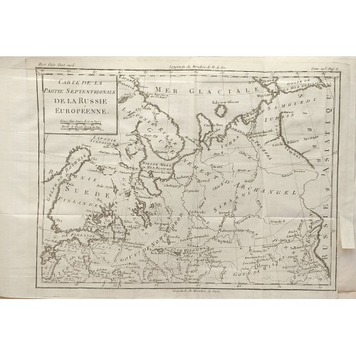
Carte de la Partie Septentrionale de la Russie Européenne.
Striking and highly detailed interesting Louis Brion de la Tour's 1788 copper engraved map of the northern part of the Russia Empire in Europe. Covers northern Russia, Estonia, Finland, Latvia and eastern Sweden. Notes cities, towns, rivers, lakes, bays, islands and reliefs. A simple title and mileage scales cartouche completes the map.
Source: Histoire Universlle depuis le Commencement du Monde jusqu'au Present (...). A Paris: Chez Moutard, 1788
Date: 1788 ( undated )
Dimension: Paper size approx.: cm 36,2 x 24,6
Condition: Very strong and dark impression on good paper. Paper with chains and wiremark. Map uncolored. Small margin to the top missing. Small ower margin. Wide left lateral margin. Quite right lateral margin, cut partially to the top. Corners partially missing. Small foxing. Map folded. Conditions are as you can see in the images.
Mapmaker: Louis Brion de la Tour (1743 - 1803) was the Cartographer Royal to the King of France, his official title being Ingenieur-Geographe du Roi, Despite a prolific cartographic career and several important atlases to his name, little is actually known of his life and career. Much of their work was published in partnership Louis Charles Desnos (fl. 1750 - 1790). Their most notable work is generally regarded to be his 1766 Atlas General.
Northern Russia Finland Estonia 1788 Brion De La Tour Unusual Antique Map
- Product Code: 3457
- Availability: In Stock