
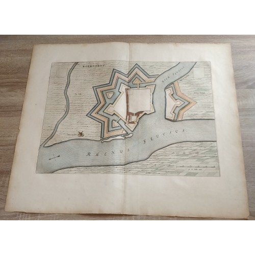
ANTIQUE ORIGINAL COPPER ENGRAVED VIEW OF RUHORT GERMANY
Cartographer/Publisher: Willem Blaeu
Date Range: 1600-1699 ; Year: 1649
Format: Atlas Map
Original/Reproduction: Antique Original
Printing Technique: Copper Plate
Type: City Map
Country/Region: Germany
RUHORT GERMANY 1649 BLAEU UNUSUAL ANTIQUE ORIGINAL COPPER ENGRAVED CITY VIEW
Description
Roeroordt.
Description: Striking and highly detailed fine unusual 1649 Blaeu's copper engraved map featuring an aerial plan of the German City of Ruhort. The plan shows the city with his fortifications and surrounding landscape. A strapwork cartouche includes the title. A simple title, two blank Armorials and a mileage scale adorn the sheet. Dutch text on the verso.
Date: 1649 ( undated )
Dimension: Paper size approx.: cm 62,8 x 54,8
Condition: Very strong and dark impression on good paper. Paper with chains and wiremarks. Map partially contemporary handcolored. Wide margins. Corners partially missing. Small foxing and browning. Small marginal tears. Map folded. Conditions are as you can see in the images.
Mapmaker: The Blaeus: Willem Janszoon, Cornelis & Joan
Willem Jansz. Blaeu and his son Joan Blaeu are the most widely known cartographic publishers of the seventeenth century.
Willem Jansz. (also written Guilielmus Janssonius) = Willem Janszoon Blaeu, was born in Uitgeest (Netherlands), near Alkmaar in 1571. He studied mathematics under Tycho Brahe and learned the theory and practice of astronomical observations and the art of instrument- and globe making.
Joan Blaeu, born in Amsterdam, 1596, became partner in his father’s book trade and printing business. In 1638 he was appointed his father’s successor in the Hydrographic Office of the V.O.C.
RUHORT GERMANY 1649 BLAEU UNUSUAL ANTIQUE ORIGINAL COPPER ENGRAVED CITY VIEW
- Product Code: 10720
- Availability: In Stock